Unbridled Energy, Untapped Potential
Southwestern Athabasca Basin | 31,314 ha | 100% Stallion Uranium Owned
Overview
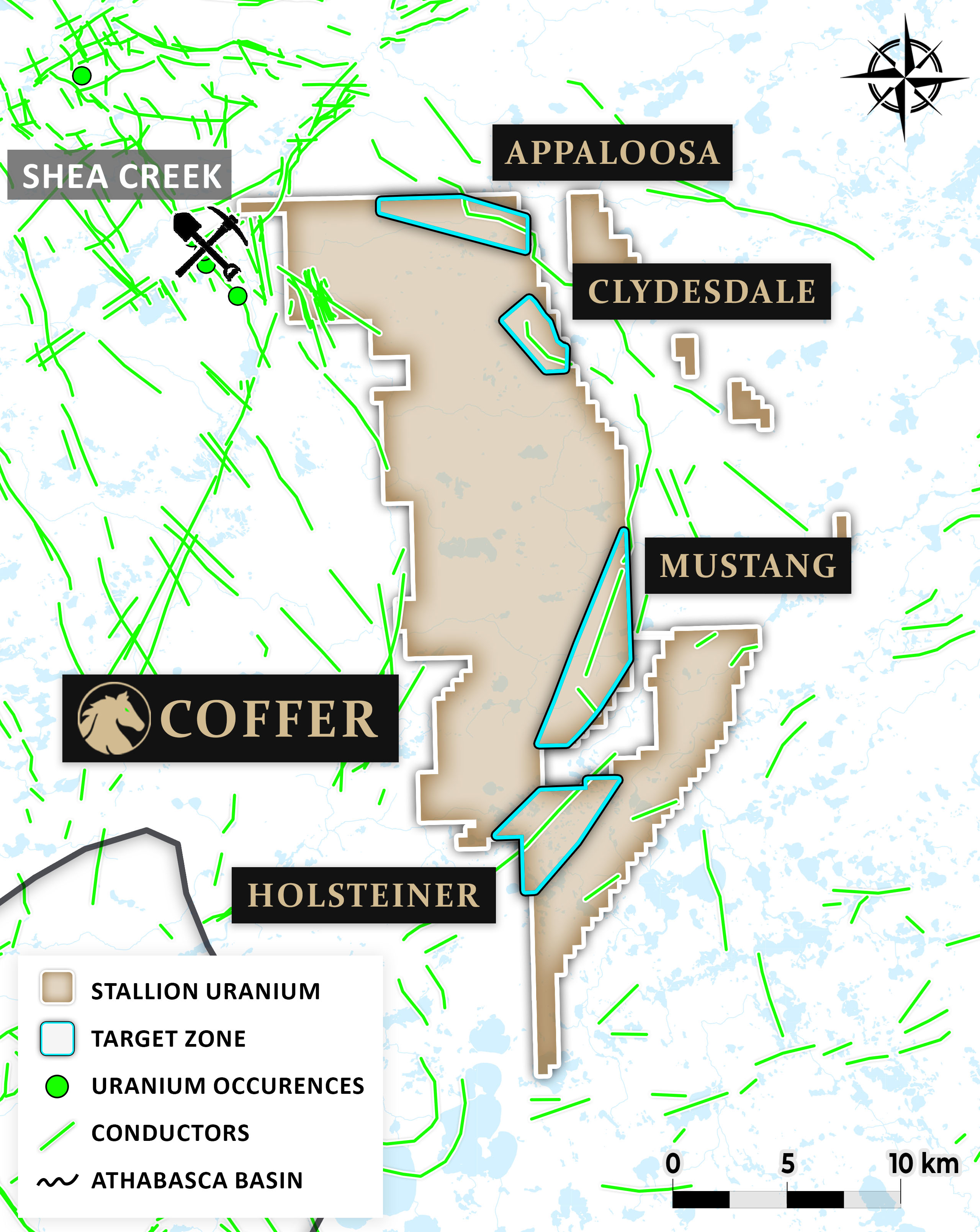
The Coffer Project comprises eight contiguous mineral claims covering 31,314 hectares in the highly prospective western Athabasca Basin. Located just 3 kilometres southeast of NexGen and Orano’s Shea Creek Project (85.05 million lbs U₃O₈, indicated and inferred) and 13 kilometres east of F3 Uranium’s JR Zone (6.97% U₃O₈ over 15.0 metres, including 18.6% over 5.5 metres), the project is surrounded by some of the most significant discoveries in the Basin.
Coffer is ideally situated at the intersection of key uranium-bearing geological features, including the Saskatoon Lake conductor and the Clearwater Domain. A VTEM™ Plus airborne survey completed in winter 2023 revealed a series of conductive trends and complex structures, including northwest–southeast trending features that mirror those seen at Shea Creek. The survey identified several high-priority zones for follow-up.
Initial drilling at the Appaloosa Target, one of the conductors identified during this survey, returned highly encouraging results. The program successfully intersected graphitic metasediments and fault structures — both key indicators for uranium mineralization in the Basin. These results validate the geophysical targeting and confirm that the system has the right geological building blocks for high-grade uranium.
In addition to Appaloosa, the property hosts major structural elements like the Beatty River Fault, and geophysical data shows similarities to uranium-rich zones along the Patterson Lake and Shea Creek trends.

Firgure 1 - Coffer Project
Target Areas
Appaloosa Target
The Appaloosa target was the first site identified by Stallion as a tier one target, aimed at advancing exploration efforts toward drill readiness. This target features a conductive trend approximately 5 km long (the Appaloosa Conductor), which shows characteristics similar to the Saskatoon Lake Conductor, known for hosting the Shea Creek Deposits. In 2024, Stallion conducted a 70 line-km ground TDEM survey over the Appaloosa target, providing a higher-resolution model of the conductive body. The conductor is situated in a gravity and magnetic low, indicating alteration that correlates with uranium mineralization. Stallion utilized these geophysical anomalies to refine its drill targets. In winter 2024, Stallion launched its first drilling project, successfully completing three drill holes totaling 2,798.2 meters. In our maiden drill program, hole CF24-002 intersected 0.12% U₃O₈ over 1.5 metres, within a broader interval of alteration and elevated radioactivity. Additionally, hole CF24-003 encountered a highly altered graphitic structure with strong pathfinder elements and elevated thorium-potassium ratios, suggesting a fertile environment. The results confirm the presence of a prospective uranium system at depth, with vectoring potential toward higher-grade zones. Follow-up drilling is being planned to test up-dip and along-strike extensions, with a focus on refining the structural controls and locating the core of mineralization.
DDH - CF24-001
Encountered anomalous radioactivity near the unconformity with a peak of 1,540cps (Counts per Second) in a 4.2m radioactive interval including 0.3m at 1,322 cps
-
Encountered anomalous radioactivity in the basement of 262 cps over 4m
-
Hit the unconformity at 762.6m and completed at a depth of 829.2m
-
Highly prospective geology encountered
Table 1: Downhole Total Gamma Results from CF24-001


Figure 1: Hole CF24-001 - Red Square is the radioactive core and hematite alteration (1,322cps with downhole probe), Blue Square is clay alteration associated with stockwork fractures, Green Square is chlorite and clay coated fracture surface
DDH - CF24-003
-
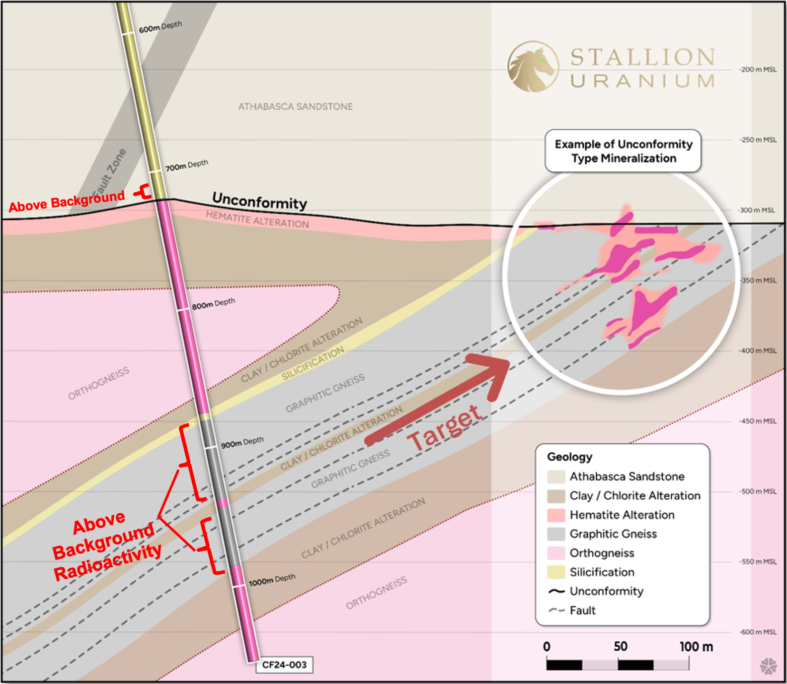
Intersected conductive structure over 94.7m, highlighting large SW dipping structure.
-
Encountered above background radioactivity near the unconformity and in graphitic structure
-
Hit the unconformity at 720m, graphitic structure at 880m and completed at a depth of 1,055m

Figure 2: Cross-section of CF24-003 with illustration of Anne Deposit (Shea Creek) as target area

Figure 3: 2024 Drill Hole Locations
Clydesdale Target
Clydesdale is defined by robust EM conductors and significant structural offsets, often associated with uranium mineralization in the Basin. With its depth potential and favorable geologic setting near the Clearwater Domain contact, Clydesdale represents a large-scale opportunity. Upcoming work will focus on refining targets and prioritizing drill locations.
Holstiener Target
The Holsteiner Target strategically located along the interpreted extension of a fertile uranium corridor, just east of the Clearwater Domain—one of the most productive structural zones in the southwestern Athabasca Basin. This positioning places Holsteiner in a comparable geological setting to F3 Uranium’s JR Zone, where high-grade mineralization (6.97% U₃O₈ over 15.0 m) was discovered along a similar structural trend.
Early-stage geophysics at Holsteiner has identified multiple northeast-trending conductor systems, crosscutting faults, and subtle resistivity lows—features that mirror those observed at the JR Zone. These intersections represent ideal conditions for fluid movement, reductant interaction, and uranium deposition.
Ongoing geophysical modeling and groundwork are being prioritized to delineate targets for initial drilling, with the goal of testing these high-potential structural intersections in the next phase of exploration.
Mustang Target
Located near key regional trends, the Mustang Target is marked by northeast-southwest structural intersections and pronounced basement conductors. These elements create an ideal trap for uranium-bearing fluids. Mustang is currently undergoing advanced interpretation, with a ground electromagnetic survey planned to test key anomalies at depth.

Figure 4: Coffer Project - Magentic Tilt Derivative over First Vertical Derivative
Exploration Roadmap
Stallion’s exploration plan at Coffer is moving forward aggressively. Phase 1 has delivered clear targeting data, and Phase 2 will focus on de-risking and drill testing the highest-priority conductors, especially those adjacent to the Clearwater Domain and parallel to the Saskatoon Lake trend. With strong early technical indicators and proximity to world-class assets, the Coffer Project is positioned as a potential cornerstone in Stallion’s discovery pipeline.
- Complete AFMAG EM survey to identify overlooked conductive corridors
- Completion of Ground EM, and gravity surveys across priority areas
- 3D modeling of conductors, magnetic breaks, and resistivity lows
- Identification of basement-rooted structures and alteration footprints
- Target refinement at Appaloosa, Mustang, and Holsteiner
- Integration with geophysics to rank drill-ready targets
- Initial drilling at Appaloosa confirms alteration and uranium-bearing structures
- Focused drilling planned for Mustang, and Clydesdale
- Downhole geophysics to refine structural controls and mineralization vectors
